
Height Map
A height map is a grid of points that are triangulated to form a surface. Because the surface over any point is found directly from the grid, collision checking is very efficient, and it is the recommended way to create terrain. A height map is always a static object. Height samples are stored row by row: the sample at grid index (x, y) is height[y * xSamples + x].
A sample may be NaN or infinite to leave a hole. Each cell is cut into two triangles along the diagonal from grid index (x + 1, y) to (x, y + 1), and a triangle with such a corner is not part of the surface: bodies, granular media and rays pass through it, whichever non-finite value the sample holds. The samples are stored unchanged, so getHeight() returns NaN or infinity there.
Position and orientation
The grid lives in the height map's own frame. It is centered at (centerX, centerY) there, the center given when the map is created or updated (getCenterX(), getCenterY()), and the heights rise along the frame's z axis. Like every other object, the height map is placed by the pose of its frame: setPosition(x, y, z) moves the frame origin and setOrientation(...) rotates the frame about that origin. With the position (centerX, centerY) in the world, and getComPosition() returns the world position of the grid center. A map created around the frame origin (centerX = centerY = 0) therefore rotates about its own center, while a map centered elsewhere swings around the origin, like a mesh whose vertices lie away from its body frame origin.
// a 4 m x 4 m map centered at (10, 0), raised by 0.5 m: move the frame, not the center
auto* map = world.addHeightMap(41, 41, 4.0, 4.0, 10.0, 0.0, heights);
map->setPosition(0.0, 0.0, 0.5);
// the same placement built around the frame origin, so it can be tilted about its center
auto* tilted = world.addHeightMap(41, 41, 4.0, 4.0, 0.0, 0.0, heights);
tilted->setPosition(10.0, 0.0, 0.5);
tilted->setOrientation(Eigen::Matrix3d(Eigen::AngleAxisd(0.2, Eigen::Vector3d::UnitY())));
Any rotation is allowed: a tilted map is a slope, a map rotated 90 degrees about x is a wall, and one rotated 180 degrees is a ceiling. A world XML file sets the orientation with the quat attribute of the height map.
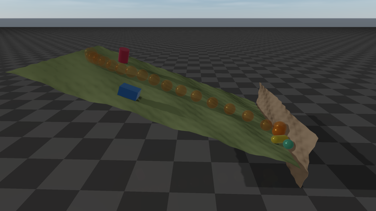
Two rotated height maps: a slope tilted 20 degrees and a wall at its foot. The box and the cylinder rest on the slope, held by friction, while the ball (its descent shown light to dark), the capsule and the small sphere roll and slide down and stop against the wall.
Everything that touches the surface follows the orientation: contacts with every shape, ray tests and the sensors built on them, swept CCD, granular particles, and rendering in rayrai and the TCP viewer. A scene on a rotated map moves like the same scene on the unrotated map, with every body and gravity rotated along with it; the two agree to rounding error. A height map is one-sided whatever its orientation: everything below the surface, along the local -z axis, is inside the terrain, and a body that ends up there is pushed back out through the surface.
Querying the surface
You can query the surface at a world-frame (x, y) position:
- height:
getHeight(x, y)(visual height) andgetContactHeight(x, y)(collision surface; the two differ only after a visual-only update) - normal vector:
getNormal(x, y, normal)(collision surface, written to the output argument) - color:
getColor(x, y)
These queries ignore the orientation by design: they read the height field as if only the translation were applied, so (x, y) addresses the grid, centered at the position plus (centerX, centerY), whether or not the map is rotated. To evaluate a rotated map, query its unrotated coordinates and rotate the result about the origin getPosition()):
- the surface point above
(x, y)of the unrotated map iswith = getHeight(x, y), and its normal istimes the result of getNormal(x, y, normal); - a world point
has the unrotated coordinates ; it is above the surface if their z exceeds getHeightat their x and y.
// the point 0.5 m above the rotated surface at the unrotated map's (x, y)
const Eigen::Vector3d o = heightMap->getPosition();
const Eigen::Matrix3d R = heightMap->getRotationMatrix();
raisim::Vec<3> normal;
heightMap->getNormal(x, y, normal);
const Eigen::Vector3d surface = o + R * (Eigen::Vector3d(x, y, heightMap->getHeight(x, y)) - o);
const Eigen::Vector3d above = surface + 0.5 * R * normal.e();
Runtime updates
update(...) changes the visual and collision height data; it cannot change the number of samples. The supplied height vector must contain exactly getXSamples() * getYSamples() finite entries; invalid input is ignored with a warning and leaves the existing map unchanged.
For visualization-only streaming, updateVisualHeight(...) replaces the full visual height array and updateVisualHeightPatch(...) updates an inclusive rectangular sample range without rebuilding collision. Both require the center and size arguments to match the current ones; the center, like that of update(...), is in the height map frame (getCenterX(), getCenterY()). The patch method receives the full row-major height array and copies only the requested range; when every sample in the range keeps its value (bit for bit), the map reports no update. Per-vertex colors use setColor(...); after a full color map has been initialized, setColorPatch(...) updates a tightly packed rectangular color range.
Renderers follow height edits through getHeightRowRevisions(): one revision per sample row, advanced whenever a height in that row changes, by any of the update methods or by a deformable terrain sinking. Unlike the update flags and the dirty region that RaisimServer reads and clears, the revisions are never cleared, so any number of readers can track them and redraw only the edited rows.
Example
- Height Map Using a PNG File
- Height Map Using Raw Values
- Height Map Using the Terrain Generator
- Height Map Using a Text File